Maps & Guides - Mount Washington Alpine Resort

MAPS & GUIDES

Know where to go with Trail Maps & Resort Guides

Mt. Washington Alpine Resort is a year-round recreation destination located on Vancouver Island, British Columbia.  In the winter guests enjoy accessing over 1,700 acres and 505 vertical metres of alpine terrain, 55kms of cross-country skiing, and 25kms of snowshoeing trails along with a dedicated Nordic lodge, Tube Park and Fat Bike trails. Learn more about resort terrain and offerings with trail map information below. Maps are also easily accessible from the Mount Washington Mobile App.

Summer Maps

Download Map

Bike Park
Preview your entire ride from top to bottom.

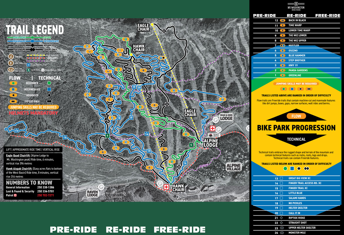
Download or view our Bike Park map to preview your entire ride. To reduce paper waste, and be sustainable we would invite our guests to utilize the Trailforks app to navigate the bike park, or download this map and keep it on their device. If you require a printed version of this map save it and print as needed.

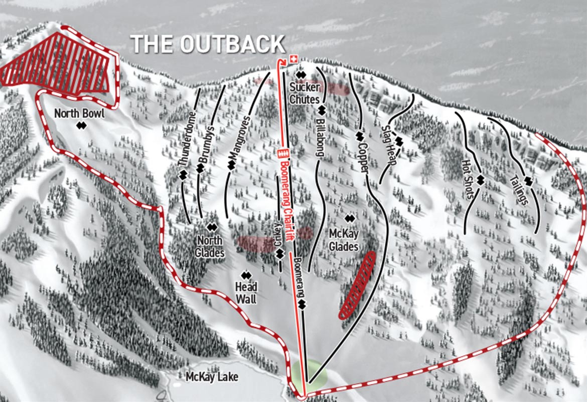
All routes within the Bike Park are designated by colour-coded trail markers at the start of each descent. Trails with an orange oval indicate freeride trails with man-made features and may require jumping skills. Work your way up to more advanced trails and features based on your progression, skill and comfort level.

Download Full Map
Download Map

Summer Hiking Map
Preview our hiking trails at Mount Washington

Download or view our hiking trails map to preview your adventure on Mount Washington. Reduce paper waste and save this map to your device. These maps are not to scale and only meant to give a general idea on the trail direction and location. The trails are marked and flagged on hill.

To determine what you need to bring on a day hike, think about how far you plan to hike, how remote the location is and what the weather forecast has in store. In general, the longer and/or more remote the hike is and the more inclement the weather, the more clothing, gear, food and water you’re going to want. Mountain conditions can change quickly and unexpectedl
Download Full Map
Download Map

Ziptour
Preview the ride from top to bottom

Download or view our Ziptour map to preview the entire ride. A one-of-a-kind, bucket-list-worthy, high-flying adventure! Experience Vancouver Island's longest combined and most thrilling zip line tour spanning across the stunning views of Mount Washington Alpine Resort. On the Eagle's Flight ZipTour, enjoy 4 unique spans of zip lines with the ability to control your own speeds to throttle for thrills or hold back to savour the views. Unfold your wings and soar with the eagles this summer!
Download Full Map
Alpine Disc Golf Map

Disc Golf
Alpine Course Map

From the top of Eagle Chair, purchase Scenic Chairlift Access or ride free as a Mountain Pass Holder. 11 Hole Black Diamond course for advanced players leads you down to the Whiskey Jack Chair & 7 Hole Blue course for novice players stays higher up the mountain for an easier hike. Steep rocky gradients on ski runs, spotter recommended on downhill holes. Click to view scorecards and the course map on the UDisc website or mobile app. Discs can be rented or purchased from Outdoor Elements retail store.
View UDisc Map
Lodge Disc Golf Map

Disc Golf
Lodge Course Map

From the Alpine Lodge Base. 9 Hole Green course perfect for beginner players leads you around the base of Mt. Washington and above the patio courtyard. Click to view scorecards and the course map on the UDisc website or mobile app. Discs can be rented or purchased from Outdoor Elements retail store.
View UDisc Map

Resort Maps

Download Map

Village Map
Parking, village properties and area

Download or view the Village Accommodation and surrounding area building map to find your way around the mountain at Mount Washington Alpine Resort
Download Full Map

Winter Maps

Download Map

Full Alpine
Frontside and Outback Trail Maps

Download or view our 2022.23 Full Alpine Map to find your way around the Strathcona Park and the mountain at Mount Washington Alpine Resort. n the winter guests enjoy accessing over 1,700 acres and 505 vertical metres of alpine terrain, 55kms of cross-country skiing, and 25kms of snowshoeing trails along with a dedicated Nordic lodge, Tube Park and Fat Bike trails.

Download for Mobile

Download Full Map
Download Map

Alpine Winter
Trail Map

Download or view our  Alpine Winter Map to find your way around the mountain at Mount Washington Alpine Resort. In the winter guests enjoy accessing over 1,700 acres and 505 vertical metres of alpine terrain, 55kms of cross-country skiing, and 25kms of snowshoeing trails along with a dedicated Nordic lodge, Tube Park and Fat Bike trails.

Download for Mobile

Download Map
Download Map

The Outback
Trail Map

Download or view our Outback Terrain Winter Map to find your way around the backside mountain terrain at Mount Washington Alpine Resort. The Boomerang Chair is a unique down-and-back lift providing access to this double-black diamond terrain.

Download for Mobile

Download Map
Download Map

Full Nordic
Cross Country, Snowshoe, and Fat Bike Map

Download or view our Full Nordic Map to find your way around the Strathcona Park and the mountain at Mount Washington Alpine Resort. n the winter guests enjoy accessing over 1,700 acres and 505 vertical metres of alpine terrain, 55kms of cross-country skiing, and 25kms of snowshoeing trails along with a dedicated Nordic lodge, Tube Park and Fat Bike trails.

Download for Mobile

Download Full Map
Download Map

Nordic Trail Map
& Fat Bike Trails

Download or view our Nordic & Fat Bike Trail Map to find your way around the Strathcona Park and the mountain at Mount Washington Alpine Resort. In the winter guests enjoy accessing over 1,700 acres and 505 vertical metres of alpine terrain, 55kms of cross-country skiing, and 25 kms of snowshoeing trails along with a dedicated Nordic lodge, Tube Park and Fat Bike trails.

Download for Mobile

Download Map
Download Map

Snowshoe
Trail Map

Download or view our Snowshoe Trail Map to find your way around the Strathcona Park and the mountain at Mount Washington Alpine Resort. n the winter guests enjoy accessing over 1,700 acres and 505 vertical metres of alpine terrain, 55kms of cross-country skiing, and 25kms of snowshoeing trails along with a dedicated Nordic lodge, Tube Park and Fat Bike trails.

Download for Mobile

Download Map

STAY INFORMED

Subscribe to receive emails from us to stay in the know!

News is sent early to our valued email community.

Subscribe to be the first notified about mountain product sales, and receive snow reports, newsletters, event information and other special promotions.

Already signed up? Thanks for being part of the MW community! Use our Preference Centre to manage your subscription and customize how you stay informed.

User tip: Add Mount Washington ski@mountwashington.ca to your email contact list to ensure you never miss a message.

All delivered to your inbox:

Events & Accommodation

Events & Accommodation

Learn about upcoming events, holiday celebrations, and other special offers to make your mountain experiences memorable.
Tickets, Passes & Perks

Tickets, Passes & Perks

Get informed of sales for the best deals, receive pass holder perk info, and all the insider scoops so you can ski/ride more.
Snow & Conditions

Snow & Conditions

Early morning snow info when you need it! Sign up for daily reports or receive powder alerts for those days you need to call in sick for work...

Our Sponsors

Rossignol
Helly Hansen
Quality Foods
Coke a Cola
Mosaic Forest Management