


Conditions & Terrain
Bike Park Conditions
Right Now
Live Trail Status
Pulled live from the mountain’s trail-reporting feed and refreshed through the day. Easiest More difficult Most difficult Experts only
- Green line Open
- Panda Gardens Open
- Hustler Open
- Blue Hammer Open
- HWY 19 Open
- Helter Skelter Open
- Little Blue Open
- Salami Hands Open
- Osezno Open
- Step Brother Open
- Finger Trail Open
- Skills Park Open
- Call It In Open
- Eagle Skills Area Open
- Time Warp Open
- Lower Time Warp Open
- Riptide Ridge Open
- Straight Shot Open
- The Wiz Lower Open
- The Wiz Upper Open
- Back In Black Open
- Upper Monster Mile Open
- Upper Helter Skelter Open
- Lower Monster Mile Open


Explore the Terrain
Trail Guide
Every descent in the park, grouped by difficulty. Distances are trail length; conditions above show what’s open today.
Green — Easiest
The gentlest introduction to the park — mellow flow to build confidence.
Greenline
OpenSuitable for beginner and intermediate riders with gentle terrain, sweeping berms and a few small rollovers. Confidence and conditioning can be built riding this trail — take it slow and be aware of others around you.
Trailforks →Blue — More Difficult
Steeper flow and technical terrain for the progressing rider.
HWY 19
OpenThe next step in your progression to steeper grades. Slightly steeper terrain offers a natural progression to more advanced skills.
Trailforks →Call It In
OpenProgression to steeper grades with more difficult obstacles — a natural step up to more advanced skills.
Trailforks →Blue Hammer
OpenFun flow trail with berms, roller jumps, tables and a rock ride feature.
Trailforks →Hustler
OpenLarge berms, bridges, tables and roll-overs with over a km of flow to get you stoked. A Blue flow trail with Black-diamond features and ride-around options.
Trailforks →Little Blue
OpenInspired by our friends in Cumberland, this blue tech trail features a small waterfall, a creek and great alpine views of Strathcona Park — a great way to access the Hawk chair from the lodge.
Trailforks →Finger Trail
OpenThe mountain’s signature XC trail — challenging terrain with unparalleled views of Strathcona Provincial Park. Rideable without a chairlift, but a waiver and free pass must be picked up at the Alpine Lodge first.
Trailforks →Finger Trail Bi-Pass
ClosedShort bypass route.
Finger Access Road
ClosedOur main multi-use access road for the Finger Trail and the XC trails on the far west of the network.
Trailforks →Great Big View
ClosedMulti-use trail overlooking Raven Lodge with spectacular views of Strathcona Park.
Trailforks →Black — Most Difficult
Steep grades, jumps and technical features for advanced riders.
The Wiz Upper
OpenThis trail has the three R’s — roots, rocks and rollovers. Watch the Greenline crossing and yield to slower riders.
Trailforks →The Wiz Lower
OpenThe second section of the Wiz — steep, flowy berm sections with some jumps.
Trailforks →Time Warp
OpenSteep flowy berm sections with large jumps and step-ups, plus a new drop feature just before Time Warp joins the Monster Mile.
Trailforks →Lower Time Warp
OpenAccess off the Monster/Hawk connector or via Disco Road. Inspired by the former 4-Cross and Bear Claw Invitational, with large features and fall-line flow to the Hawk chair.
Trailforks →Riptide Ridge
OpenLoamy, handcrafted sub-alpine tech trail with amazing views, flowy sections and rock gardens.
Trailforks →Straight Shot
OpenA short advanced tech trail to start your day or finish your last run on the way to the Hawk chair.
Trailforks →Double Black — Experts Only
The mountain’s gnarliest freeride and tech — full armour and high skill strongly suggested.
Back In Black
OpenEntrance closed for rebuilding — look for the new rock roll on rider’s left near the mid-section. Watch for drops and features (all have ride-arounds). Full armour and a high degree of skill strongly suggested.
Trailforks →Upper Helter Skelter
OpenNow starting from the top of the Hawk chairlift and connecting to the lower sections to form one technical trail.
Trailforks →Upper Monster Mile
OpenExperts only — a technical double-black with unbeatable views from the top of the Eagle chairlift.
Trailforks →Monster Mile
ClosedThe mountain’s signature old-school freeride trail: steep, gnarly and for advanced riders only. If you’re unfamiliar, look before rolling onto any feature.
Trailforks →Skills Zones & Access
Practice areas and access routes into the park.
Eagle Skills Area
OpenBetween the Alpine Lodge and Hawk chair. Built to build confidence and familiarise riders with the park — a small drop zone plus berms and rollers like those on the mountain trails.
Hawk Skills Area
ClosedAt the corner of the Finger Trail and Back in Black.
Good to Know
Understanding Trail Signage
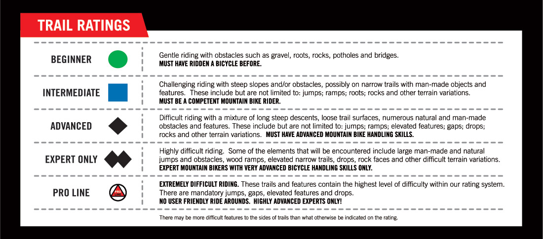
All routes within the Bike Park are marked by colour-coded trail signs at the start of each descent — green (easiest), blue (more difficult), black diamond (most difficult) and double black diamond (experts only).
Trails marked with an orange oval are freeride trails with man-made features and may require jumping skills. Work your way up to more advanced trails and features based on your progression, skill and comfort level.
Downloads
Trail Maps
Preview your entire ride from top to bottom. To cut paper waste we invite riders to use the Trailforks app to navigate the park, or download the map and keep it on your device.
See It Live